File:Van Veldhuizen.jpg

| Author | Affiliation |
|---|---|
| Jacob Van Veldhuizen | University of Colorado Museum of Natural History |
| Chelsea Trenbeath | University of Colorado Museum of Natural History |
| Chelsea Herbertson | Bureau of Land Management Colorado State Office |
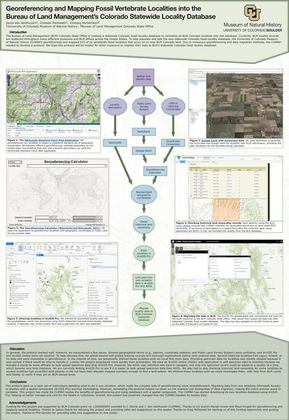
Abstract: The University of Colorado Museum of Natural History (CUMNH) is collaborating with the Bureau of Land Management (BLM) Colorado State Office to georeference and map 615 BLM Colorado fossil vertebrate localities at the CUMNH that occur on or near BLM Colorado land and migrate the locality data to a newly-created statewide paleontology locality database. The BLM is in the process of developing several statewide paleontology locality databases because locality records are scattered throughout many different museums and BLM offices across the United States. Statewide paleontology locality databases centralize and standardize BLM locality data, helping BLM make more informed decisions on the care, management, and conservation of paleontological resources found on their lands. First, localities were georeferenced to provide a consistent and standard set of geographic coordinates. Different georeferencing procedures were followed depending on the data type of the locality (e.g., geographic coordinates, Public Land Survey System, locality description). Once georeferenced, the localities were mapped into an ArcGIS Pro geodatabase structured using BLM’s statewide paleontology locality database schema. Using various land ownership GIS layers and websites, the current and historic land ownership of the locality was researched to verify BLM or other owner’s land ownership through time. Any localities that were collected when BLM did not manage the land were excluded from the ArcGIS Pro geodatabase. A PDF of the physical locality form and a specimen list were attached to a locality’s ArcGIS Pro record, which then serves as a single place for the original and georeferenced locality data, specimens collected, and other data not part of BLM’s statewide paleontology locality database schema. The locality data and attachments were then shared with the BLM Colorado State Office via ArcGIS Pro and ArcGIS Online. Issues encountered primarily related to paucity of data for old localities, but we remedied this by shelving the locality until more data for the locality is found. None of the issues slowed down the process. Eventually, the locality data shared with the BLM Colorado State Office will become a part of a national localities database for a project effort called RAPTOR (Recreation and Permit Tracking Online Reporting).
File history
Click on a date/time to view the file as it appeared at that time.
| Date/Time | Thumbnail | Dimensions | User | Comment | |
|---|---|---|---|---|---|
| current | 15:58, 18 May 2023 |  | 8,000 × 11,600 (6.01 MB) | EmilyBraker (Talk | contribs) | {| class="wikitable" |+ SPNHC 2022 Edinburgh Poster: '''Georeferencing and Mapping Fossil Vertebrate Localities into the Bureau of Land Management’s Colorado Statewide Locality Database''' ! Author ! Affiliation |- ! Jacob Van Veldhuizen | Universi... |
- You cannot overwrite this file.
File usage
The following page links to this file: